Wetlands Knowledge Search Results
Resource
This presentation discusses the need for a multi-level classification for boreal wetlands and accurate change detection.
Resource
This presentation discusses the Alberta water extent monitoring pilot study, with the goal to create a database that has the potential for implementation at a provincial level.
Resource
This public symposium covers Alberta's progress to improve its flood and drought resiliency, including the role of natural solutions. NOTE: This is a 4 hour video with multiple presenters
Resource
This presentation was a part of the Petroleum Technology Alliance of Canada, Hydraulic Fracturing in Western Canada: an Environmental Perspective Forum, in May of 2014.
Resource
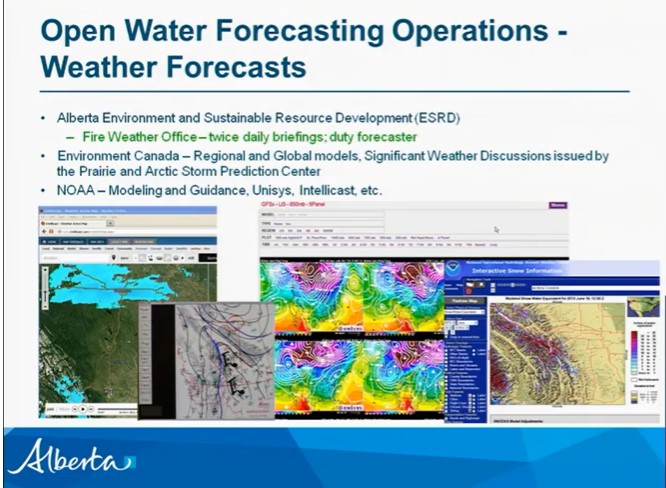
This presentation talks about Bathymetric LiDARs for Hydrographic Mapping with a focus on ALTM systems and data fusion.
Resource
Dr. Chris Hopkinson introduces a series of seven videos that covers the topic of LiDAR and its application in water resources planning and monitoring.
Resource
This presentation discusses Synthetic-aperture radar (SAR) and Water resources.
Resource
This presentation discusses discusses SAR polarimetry for flooded vegetation and the the scattering properties of wetlands.
Resource
This presentation discusses SAR/InSAR water extent mapping, mapping vegetation as water, and how water mapping changes in the wetlands.
Resource
This presentation discusses environmental contamination issues in the wetlands of Nova Scotia stemming from gold mining in the early 1900s and detection of contamination.
Resource
This presentation describes the process of delineating, extracting and mapping small bodies of water in a SAR image.
Resource
This report summarizes the results of a three-year research project to evaluate the effects of forest resource roads and construction techniques on wetland hydrology in Manitoba's boreal forest.
Resource
Authors
Jeff Wilson
Scott Heckbert
Craig Aumann
Marius Cutlac
William Donahue
Mike Kennedy
Yongbo Liu
Daiyuan Pan
Wanhong Yang
The model documentation summarizes the data, variables and assumptions required to capture how water purification services are provided across landscapes in Alberta
Resource
Rivers in Southern Alberta are vulnerable to climate change because much of the river water originates as snow in the eastern slopes of the Rocky Mountains.
Resource
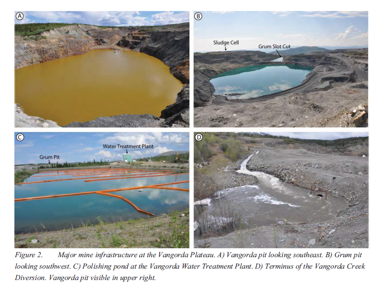
The Vangorda Plateau at the Faro Mine Complex contains two open pits that, starting in 2013, will both require dewatering. Since mine abandonment in 1998, water levels in Vangorda pit have been...
Resource
The Oil Sands Research and Information Network (OSRIN) is a university-based, independent organization that compiles, interprets and analyses available knowledge about managing the environmental...
Resource
Passive biological treatments have been proposed as a possible efficient and cost effective treatment method for metal bearing water discharged from mine sites after closure. Several biofilters are...
Resource
Authors
Jean-Marie Sobze
Marie-Eve Gauthier
Bin Xu
Amanda Schoonmaker
Site re-vegetation is an important phase in peatland restoration. Prior to re-vegetating a peatland site, appropriate methods should be used to adjust the soil and address the hydrologic disturbance...
Resource
Authors
Evgeniya Smirnova
Isabelle Demers
Medard Bouda
Mostafa Benzaazoua
Mamert Mbonimpa
Guylaine Bois
The use of the lime neutralization process is a common technique to treat acid mine drainage (AMD) generated by sulphidic mine wastes. The AMD-contaminated water collected on the mine site is...
Resource
Authors
Sylvain Ménard
Marcel Darveau
Louis Imbeau
Resource Date:
December
2013
This study quantified the distribution of wetland and aquatic wildlife-habitat landscape types in boreal Quebec and determined how wildlife habitats vary among climatic regimes and landforms.