
Search Results
Displaying:
21 - 40 of 64

Low-impact Line Construction Retains and Speeds Recovery of Trees on Seismic Lines in Forested Peatlands
Resource
Seismic lines, linear features originating from the oil and gas industry for energy exploration, pose a substantial management challenge due to their collective impact on biogeochemical cycles, plant...

Monitoring Procedures for Wellsite, In-Situ Oil Sands and Coal Mine Reclamation in Alberta – December 2014 Update
Resource
Scope of the project is to develop a geomatics-based monitoring system to support the Government of Alberta’s efforts for monitoring reclamation success. Software will support decision making process

Natural Recovery on Low Impact Seismic Lines in Northeast British Columbia
Project
Contact
Project Description WSP Golder (formerly Golder Associates Ltd) and Explor were supported by the Research and Effectiveness Monitoring Board (REMB) of the BCIP initiative, with funding provided by the...

Natural Recovery on Low Impact Seismic Lines in Northeast British Columbia
Resource
WSP Golder (formerly Golder Associates Ltd) and Explor were supported by the Research and Effectiveness Monitoring Board (REMB) of the BCIP initiative, with funding provided by the BC Oil and Gas...

Pinpoint Allows Seismic to go Lineless
Resource
If you live in western Canada chances are you’ve seen a seismic line. Narrow corridors cut through the bush, seismic lines facilitate access for people and equipment to conduct geophysical surveys to...
Recreational Trail Impacts on the Plant Communities of Castle and Castle Wildland Provincial Parks in Southern Alberta
Resource
I measured the effect of recreational trails on plant species richness, community composition, and the presence of exotic and rare species in the Castle Provincial Parks of Alberta, Canada, by...

Seismic Line Impacts on Proximal Boreal Forest and Wetland Environments in Alberta
Resource
This resource is available on an external database and may require a paid subscription to access it. It is included on the CCLM to support our goal of capturing and sharing the breadth of all...

Shortening Fire Return Interval Predisposes West-Central Canadian Boreal Peatlands to More Rapid Vegetation Growth and Transition to Forest Cover
Resource
Climate change in northern latitudes is increasing the vulnerability of peatlands and the riparian transition zones between peatlands and upland forests (referred to as ecotones) to greater frequency...

Shrub Changes with Proximity to Anthropogenic Disturbance in Boreal Wetlands Determined Using Bi-temporal Airborne LiDAR in the Oil Sands Region, Alberta Canada
Resource
Bi-temporal LiDAR data used to identify correspondence between density of anthropogenic disturbances, wetland shape complexity and changes in vegetation height within >1800 wetlands near Fort McKay
Soluble Calcium and Sulphate Excesses Related to Stress in Pinus contorta on Peat Amendments of Reclaimed Landscapes in the Boreal Oil Sands Region
Resource
Results indicated a negative relationship among pine performance with increasing soluble calcium and available sulphate-S

Spatial and Temporal Changes in Seasonal Range Attributes in a Declining Barren-ground Caribou Herd
Resource
From 1996 to 2015 the Bathurst caribou herd has declined from approximately 349,000 to 20,000 animals. Aboriginal traditional knowledge (TK) has recently observed the later arrival of the herd below...

The Biophysical Climate Mitigation Potential of Boreal Peatlands During the Growing Season
Resource
Peatlands and forests cover large areas of the boreal biome and are critical for global climate regulation. They also regulate regional climate through heat and water vapour exchange with the...
Theses - University of Lethbridge
Project
Organization:
Electronic theses from University of Lethbridge students.
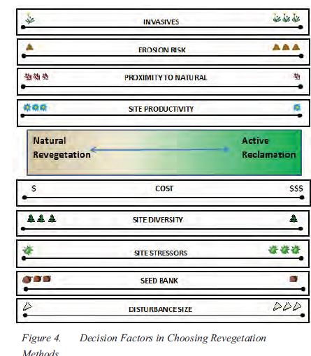
Tools for Arctic Revegetation: What's in Your Toolbox?
Resource
Revegetation in arctic climates is a challenge for many reasons. There are two approaches to arctic revegetation: natural regeneration and active reclamation. Natural regeneration is an inexpensive...
Tree Species Mapping Around Reclaimed Oil and Gas Wells Sites Using Hyperspectral and Light Detection and Ranging (LiDAR) Remote Sensing
Resource
Oil and gas activities in Alberta require disturbing forested lands, among other ecosystems, in order to extract resources. Due to the number of oil and gas sites requiring reclamation, monitoring can...

Video - A multi-level classification for Boreal wetlands
Resource
This presentation discusses the need for a multi-level classification for boreal wetlands and accurate change detection.
