
Search Results
Displaying:
101 - 120 of 267
Forage Quality of Seeded Native Grasses in the Fall Season on the Canadian Prairie Provinces
Resource
There is renewed interest in re-seeding native grasses in the prairie region of western Canada but there is limited information on their forage quality for fall grazing. We evaluated forage quality in...

Forest Ecosystem Monitoring in Saskatchewan and Alberta: Identification of Aquatic Elements and Sampling Protocols
Resource
This chapter describes aquatic elements and sampling protocols that could be used to monitor forested stream ecosystems in Alberta and Saskatchewan

Functional Response of Wolves to Human Development Across Boreal North America
Resource
Study testing wolf responses to infrastructure related to natural resources development across Canada's boreal ecosystems.

Governance as a Driver of Change in the Canadian Boreal Zone
Resource
The Canadian boreal forest is primarily public land, owned and managed by provincial governments on behalf of the public interest. Boreal forest governance consists of a complex patchwork of federal...

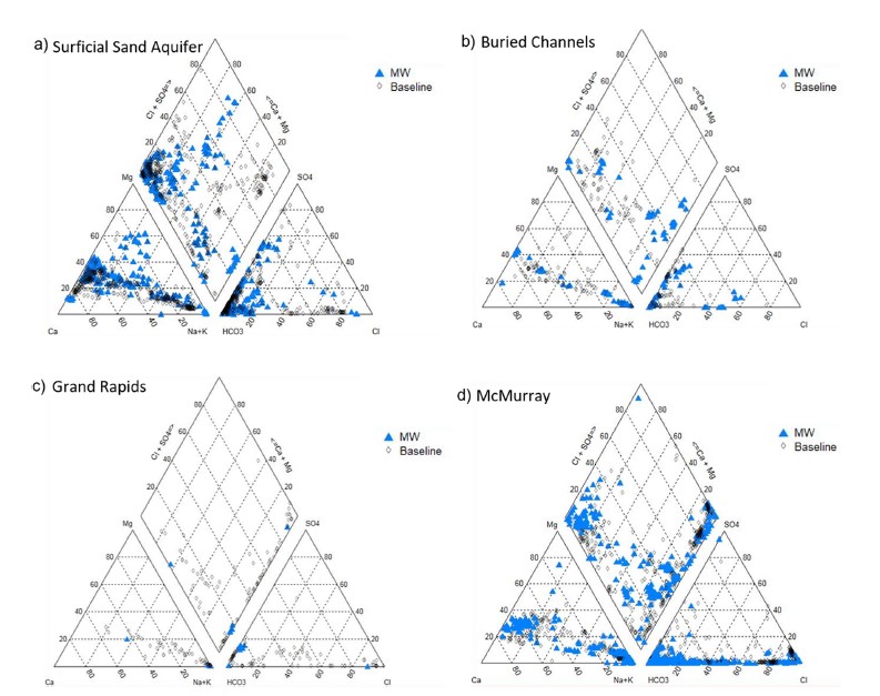
Groundwater Monitoring Near Oil Sands Development: Insights From Regional Water Quality Datasets in the Alberta Oil Sands Region (AOSR)
Resource
Groundwater quality data for the AOSR are compiled and interpreted to provide information on regional water quality to inform groundwater monitoring and land use planning. A database of 546 water...

Groundwater Monitoring Near Oil Sands Development: Insights from Regional Water Quality Datasets in the Alberta Oil Sands Region (AOSR)
Resource
Groundwater quality data for the AOSR are compiled and interpreted to provide information on regional water quality to inform groundwater monitoring and land use planning. A database of 546 water...
Guide to Variance Justifications for Reclamation Certification of Wellsites and Associated Facilities on Forested Land: Case Studies
Resource
This document provides five case studies to show how the Guide to Variance Justifications for Reclamation Certification would be applied to real‐world examples of reclamation certificate applications

Guide to Variance Justifications for Reclamation Certification of Wellsites and Associated Facilities on Forested Land
Resource
This document was developed to provide guidance and consistency in applying for and approving variance requests for reclamation certification of upland sites from an ecological perspective.

Guide to Variance Justifications for Reclamation Certification of Wellsites and Associated Facilities: Stakeholder Review and Field Verification
Resource
Practitioners tested the Guide to Variance Justifications on four of those sites; three had been previously approved and one had been submitted and was pending a decision.

Harnessing the Innovation System to Support Efficient Upstream Oil and Gas Wellsite Assessment, Remediation and Reclamation
Resource
On June 25, 2018, InnoTech Alberta, the Environmental Services Association of Alberta (ESSA) and Alberta Economic Development and Trade co-hosted a workshop entitled Harnessing the Innovation System...

Health Survey of Boreal Caribou (Rangifer tarandus caribou) in Northeastern British Columbia, Canada
Resource
Boreal woodland caribou (Rangifer tarandus caribou) are listed as threatened across Canada, and a basic understanding of their health status is lacking. From December 2012 to April 2013, we...

High Prevalence of Prion Protein Genotype Associated with Resistance to Chronic Wasting Disease in One Alberta Woodland Caribou Population
Resource
Chronic wasting disease (CWD) is a prion disease found in deer, elk and moose in North America and since recently, wild reindeer in Norway. Caribou are at-risk to encounter CWD in areas such as...
High-resolution Satellite Imagery Applied to Monitoring Revegetation of Oil-sands-exploration Well Pads
Resource
Project demonstrated that high-spatial-resolution satellite imagery could be used to develop accurate land-cover classifications on reclaimed in-situ operations

HydroGeoSim: A Water Purification Geosimulation Modelling Platform
Resource
The model documentation summarizes the data, variables and assumptions required to capture how water purification services are provided across landscapes in Alberta

Identification and Characterization of Abandoned Padded Wellsites Using Remote Sensing
Resource
In 2018, the Petroleum Technology Alliance of Canada (PTAC) initiated a multi-stage project on the reclamation certification process for sites that were constructed using imported mineral soil pads in...

Impacts of Land-use Management on Ecosystem Services and Biodiversity: An Agent-based Modelling Approach
Resource
This ecosystem service modelling system allows stakeholders to evaluate the opportunities and trade-offs to make informed decisions for achieving land-use planning goals.
