Land Management Search Results
Resource
Authors
Oil Sands Research and Information Network
Did You Know series was a means of highlighting interesting current and historical facts about development, economics and environmental management related to the oil sands.
Resource
Authors
David Polster
Chris Powter
Proceedings of the 2013 Northern Latitudes Mining Reclamation Workshop and 38 th Annual Meeting of the Canadian Land Reclamation Association. Whitehorse, Yukon, September 9 – 12, 2013
Resource
Resource Date:
September
2023
Although peatlands cover only 3% of the world's land, they store about twice as much carbon as in the biomass of all the world's forests combined. Thus, they are incredibly important especially for...
Resource
Authors
B. Ayres
Mike O'Kane
Lee Barber
D. Hiller
D. Helps
The Claude waste rock pile at Cluff Lake uranium mine in northern Saskatchewan's Athabasca basin contains ~7.2 million tonnes of waste rock, upon which an engineered enhanced store-and-release cover...
Resource
Objectives were to establish grass, shrub and tree species for evaluation of their response, particularly their reproduction response, to the climatic and edaphic conditions north of Fort McMurray
Resource
2nd year of field work and intensive laboratory and greenhouse studies contribute to a much fuller understanding of the factors related to the very successful growth of Jack Pine on sand
Resource
Authors
Stephen Moran
Terry Macyk
Mark Trudell
Margot Pigot
In 1985, a one hectare pond developed in the upland reclaimed landscape at Vesta Mine in an area where extensive ponding had not previously been observed. Because of the thickness of the spoil, about...
Resource
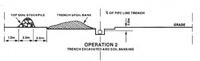
Successful reclamation of a pipeline right-of-way is contingent upon the proper material handling procedure, especially for topsoil conservation. NOVA's practice of topsoil conservation is discussed...
Resource
Authors
Stephen Moran
Mark Trudell
Terry Macyk
Daphne Cheel
The first phase of the study, which was completed in 1984, included characterization and instrumentation of two study areas: the Battle River study area, which included Diplomat, Vesta and Paintearth...
Resource
Resource Date:
August
2020
This document is part of the 360 tours project Toolkit developed by Canada's Oil Sands Innovation Alliance (COSIA) led by Cenovus Energy Inc., in collaboration with Natural Resources Canada. The...
Resource
Resource Date:
August
2020
This document is part of the 360 tours project Toolkit developed by Canada's Oil Sands Innovation Alliance (COSIA) led by Cenovus Energy Inc., in collaboration with Natural Resources Canada. The...
Resource
Authors
Mark Trudell
Stephen Moran
Terry Macyk
This is one of a series of reports that presents the findings of the Plains Hydrology and Reclamation Project (PHRP), an interdisciplinary study that focuses primarily on hydrologic aspects of the...
Resource
Authors
Brian Eaton
Tyler Muhly
Jason Fisher
Shauna-Lee Chai
Reclaimed mine sites will consist of engineered landforms (including water bodies and waterways); the long-term hydrological and ecological function of those sites may be vulnerable to beaver activity
Resource
Authors
Bonnie Drozdowski
Craig Aumann
Chris Powter
Report of a seminar to develop a collective understanding of the benefits and opportunities of Predictive Soil Mapping as they relate to Alberta
Resource
Modelling results for the regional watersheds were encouraging and demonstrate that SWATBF has the potential to be utilized as a practical tool for conducting hydrologic assessments in the oil sands
Resource
Authors
Heather Tokay
Kevin Renkema
Dean MacKenzie
Chris Powter
Bonnie Drozdowski
Natalie Shelby-James
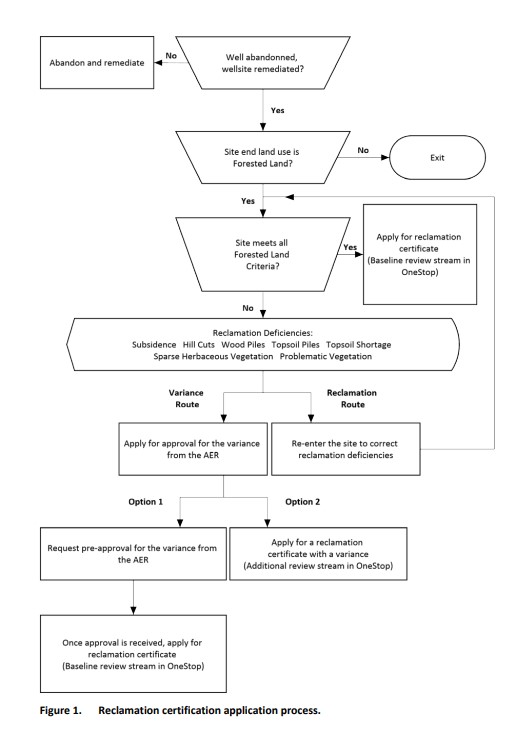
In 2021, PTAC sought verification of the Guide to Preparing Variance Justifications and stakeholders were asked to apply the document to current sites in their work portfolio.
Resource
Because of the considerable area of peatlands in Alberta, the increasing uses of peatlands for various purposes, and the potential impacts of pollutants, there is concern about the effects on the qual
Resource
Authors
Alberta Biodiversity Monitoring Institute
Boreal caribou populations are declining across Alberta and much of their Canadian range. Key factors causing this decline include a warming climate along with habitat change from industrial...
Resource
Authors
Alberta Biodiversity Monitoring Institute
Seismic lines and other linear features created by humans are thought to negatively impact woodland caribou. It is estimated that there are c. 100,000 km of conventional seismic lines in caribou...
Resource
Authors
Alberta Biodiversity Monitoring Institute
Resource Date:
January
2020
Linear features, including seismic lines, pipelines, transmission lines, roads, railways, and trails are pervasive in Alberta’s boreal forest and have been implicated as a primary factor leading to...