Land Management Search Results
Resource
Authors
Anne Naeth
Konstantin Dlusskiy
Leonard Leskiw
Chris Powter
Andy Etmanski
Humans impact everything, including our soil. We remove, mix and compact soil horizons. We add amendments, including waste materials, to replace soil or improve its health. Soils that that have been...
Resource
Authors
Kim Chapman
Rob Fleming
Nelson Thiffault
Daniel Gouge
Gordan Kayahara
Dave Morris
Wayne Bell
We present an ecological framework for classifying sites to support vegetation management decisions in the boreal and northern temperate forests of northeastern Ontario and northwestern Quebec. This...
Resource
Resource Date:
November
2023
This webinar provided a brief overview of Intensive Forest Management. It also included a panel discussion with experts who will share their knowledge on the practice.
Resource
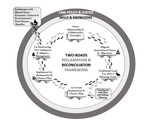
The sustainability of a landscape and its host community post-mining depends on careful and effective mine closure and reclamation planning. Such planning has the potential to support the renewal of...
Resource
Authors
Nelson Thiffault
Caludie-Maude Canuel
Michael Hoepting
James Farrell
This fact sheet provides an overview of a study on the management implications of pre-commercial thinning in balsam fir. While the effects of pre-commercial thinning on stand growth and quality are...
Resource
Authors
Kim Chapman
Rob Fleming
Nelson Thiffault
Daniel Gouge
Gordon Kayahara
Dave Morris
Wayne Bell
We present an ecological framework for classifying sites to support vegetation management decisions in the boreal and northern temperate forests of northeastern Ontario and northwestern Quebec. This...
Resource
Authors
Alex Lanki-Traikovski
Michelle Knaggs
Climate refugia are areas where the impacts of climate change may be slower to materialize, providing either permanent or temporary areas of existing habitat that are more likely to persist than...
Resource
Authors
Matthew Pyper
Katalijn MacAfee
Matthew Pyper and Katalijn MacAfee present a lecture to the Canadian Institute of Forestry on the background of the 2 Billion Trees program and various silvicultural tools and practices to increase...
Resource
Authors
Natalie Shelby-James
Sarah Thacker
Chris Powter
Paul Fuellbrandt
Tomislav Hengl
Leandro Parente
Objective is to work collaboratively with soil data users to develop the Alberta Background Soil Quality System (ABSQS) as a tool to assist industry and government in environmental management
Resource
Authors
Mark Baah-Acheamfour
Jean-Marie Sobze
The longevity of seeds in storage is modulated by the initial quality as well as the storage conditions.
Resource
A 22 slide presentation (exported as a pdf) providing an overview of effects of wind turbine development on Caribou.
Resource
Authors
Alberta Environment and Parks
Canada is a party to the UN Convention on Biological Diversity, which identifies the conservation and restoration of biological diversity as a global priority. It is incumbent on the provinces and...
Resource
Resource Date:
March
2022
In the discontinuous permafrost zone, thermokarst lakes and thermal erosion are widespread and common permafrost thaw-related phenomena. Thermokarst features are indicative of thaw sensitive...
Resource
Authors
Eric Kessel
Owen Sutton
Jonathan Price
Given the potential for moisture limited conditions due to the sub-humid regional climate, ensuring sufficient water availability in these landscapes is a principal concern. This research demonstrates...
Resource
Authors
Angeline Van Dongen
Caren Jones
Amanda Schoonmaker
Jill Harvey
Dani Degenhardt
Resource Date:
November
2022
Alberta’s forests are becoming increasingly disturbed and fragmented by the cumulative effects of anthropogenic distur�bances exacerbated by the enduring footprint of seismic lines on the landscape...
Resource
Authors
Guillermo Castilla
Ronald Hall
Rob Skakun
Michelle Filiatrault
André Beaudoin
Michael Gartrell
Lisa Smith
Kathleen Groenewegen
Chris Hopkinson
Jurjen van der Sluijs
Resource Date:
February
2022
Wall-to-wall 30 m raster maps of broad forest type, stand height, crown closure, stand volume, total volume, aboveground biomass, and stand age were created for a ~400,000 km2 area, validated with independent data, and generalized into a polygon GIS layer resembling a traditional FI map. The MVI project showed that a reasonably accurate FI map for large, remote, predominantly non-inventoried boreal regions can be obtained at a low cost by combining limited field data with remote sensing data from multiple sources.
Resource
Authors
Nick Salafsky
Robyn Irvine
Judy Boshoven
Jaclyn Lucas
Kent Prior
Jean-François Bisaillon
Becky Graham
Paul Harper
André Laurin
Amanda Lavers
Lalenia Neufeld
Richard Margoluis
Resource Date:
October
2021
There is currently a great deal of work being undertaken to collect, analyze, and synthesize available evidence about the effectiveness of conservation strategies. But substantial challenges still...
Resource
This report is adapted from a brief that was delivered in May, 2021 to the Standing Committee on Climate Change and Environmental Stewardship, an all-party committee of the New Brunswick Legislature...
Resource
Authors
Dee Patriquin
Alex Zeller
Karen Truman
Rebecca Hay
Sophie Gibbs
This document provides decision-making criteria to assist in various aspects of roadway design and operation for management of sustainable road systems
Resource
Authors
William Wadsworth
Ave Dersch
Robin Woywitka
Kisha Supernant
The Athabasca Oil Sands (AOS) region of Alberta has one of the densest accumulations of known archaeological sites, and possibly the most archaeological sites at risk, in the country. Expanding...