Wetlands Knowledge Search Results
Resource
Authors
Alberta Biodiversity Monitoring Institute
As of 2015, 29.2% of Alberta is under human footprint, up from 25.7% in 1999—that’s an average increase of about 0.22%, or around 1450 km2 (560 sections) per year.
Resource
Authors
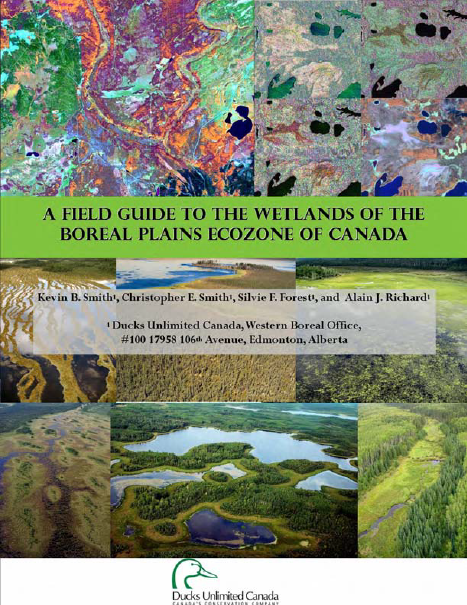
Kevin Smith
Christopher Smith
Silvie Forest
Alain Richard
This guide provides an in-depth look at Ducks Unlimited Canada's (DUC) remote-sensing satellite mapping efforts and the development of the DUC enhanced wetland classification system.
Resource
Authors
Natalie Shelby-James
Sarah Thacker
Chris Powter
Paul Fuellbrandt
Tomislav Hengl
Leandro Parente
Objective is to work collaboratively with soil data users to develop the Alberta Background Soil Quality System (ABSQS) as a tool to assist industry and government in environmental management
Resource
Authors
Alberta Biodiversity Monitoring Institute
Royal Alberta Museum
Alberta Science Network
An introduction to Alberta's wetland classifications and biodiversity, created for Alberta Science Network classroom presentations. A wetland is a part of the land that holds water temporarily or...
Resource
Authors
Aaron Sekerak
Gordon Walder
Maps showing fish collection locations, photos and details of the physical characteristics of nine streams within five watersheds (Firebag, Muskeg, Steepbank, MacKay, and Ells) in AOSERP study area
Resource
Authors
Jesse Tigner
Erin Bayne
Stan Boutin
Resource Date:
January
2014
This resource is available on an external database and may require a paid subscription to access it. It is included on the CCLM to support our goal of capturing and sharing the breadth of all...
Resource
Resource Date:
August
2021
With the support of Alberta Environment and Parks, the Alberta Biodiversity Monitoring Institute has become the trusted source for data about habitat, species, and the human footprint.
Resource
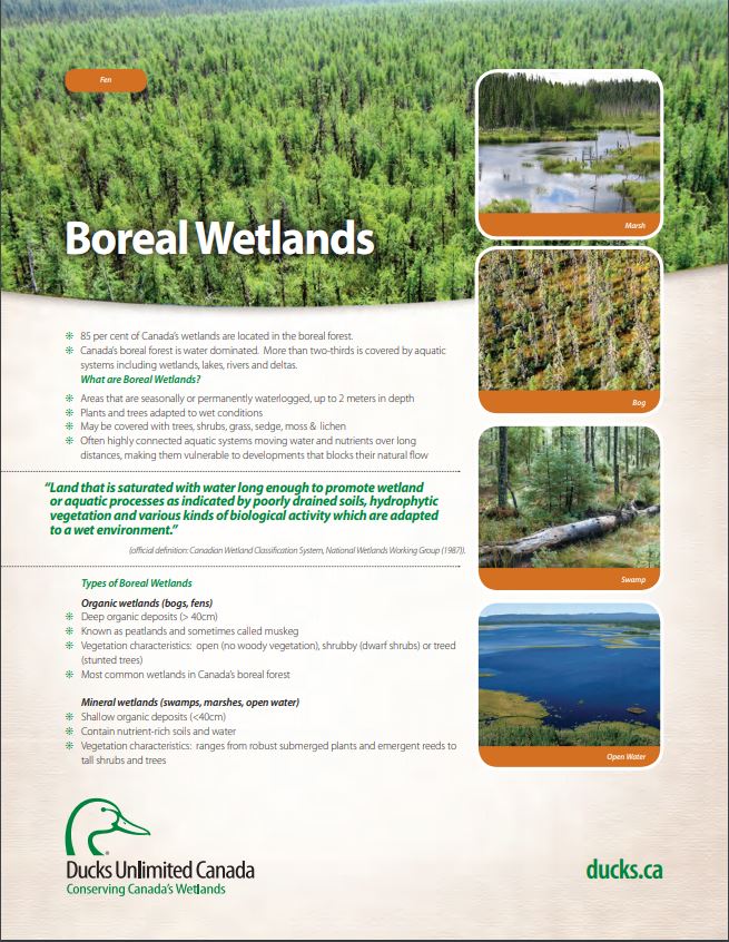
These fact sheets highlight plant, soil, and water indicators and key ecological benefits of each of the five major wetlands types.
Resource
Authors
Lauren Thompson
McKenzie Kuhn
Johanna Winder
Lucas Braga
Ryan Hutchins
Andrew Tanentzap
Vincent St. Louis
David Olefeldt
Resource Date:
January
2023
Permafrost thaw may increase the production of neurotoxic methylmercury (MeHg) in northern peatlands, but the downstream delivery of MeHg is uncertain. We quantified total mercury (THg) and MeHg...
Resource
Authors
James Saracco
Peter Pyle
Danielle Kaschube
Monica Kohler
Christine Godwin
Kenneth Foster
Habitat loss and disturbance from industrial resource development may be contributing to declines in boreal bird populations. We applied hierarchical multi-species models to data from 31 bird species...
Resource
Authors
Martin LeClerc
Mathieu Leblond
Christian Dussault
Mael Le Corre
Steeve Côté
This resource is available on an external database and may require a paid subscription to access it. It is included on the CCLM to support our goal of capturing and sharing the breadth of all...
Resource
Authors
Jason Clark
Ken Tape
Latha Baskaran
Clayton Elder
Charles Miller
Kimberley Miner
Jonathan O'Donnell
Benjamin Jones
Beaver engineering in the Arctic tundra induces hydrologic and geomorphic changes that are favorable to methane (CH 4) production. Beaver-mediated methane emissions are driven by inundation of...
Resource
Resource Date:
January
2016
This presentation provides an overview of the Ducks Unlimited Canada Enhanced Wetland Classification System, including current and potential uses for wetland conservation and management.
Resource
Ducks Unlimited Canada has been leading the effort to provide detailed and accurate wetland maps for large areas of the western boreal forest. These mapping products have become the cornerstone of DUC...
Resource
Authors
United Nations Environment Programme
Resource Date:
November
2022
Peatlands are unique and rare ecosystems that, despite only covering around 3-4% of the planet’s land surface, they contain up to one-third of the world’s soil carbon, which is twice the amount of...
Resource
Breeding bird studies using the mapping method were combined with intensive habitat quantification to determine the relative values to breeding avifauna of 21 habitat types
Resource
Authors
S. Konkolics
Melanie Dickie
Robert Serrouya
Stan Boutin
To examine the effects of forest fires on woodland caribou, we collected GPS location data on five caribou ranges in northeastern Alberta.
Resource
Authors
Larry Turchenek
J.D. Lindsay
The emphasis in this inventory is on soils and the landforms on which they occur; both are indicated on maps. Air photo interpretation and field checking have been completed
Resource
Authors
Sini-Selina Salko
Jussi Juola
Iuliia Burdun
Harri Vasander
Miina Rautiainen
Boreal peatlands store ~25 % of global soil organic carbon and host many endangered species; however, they face degradation due to climate change and anthropogenic drainage. In boreal peatlands...
Resource
Authors
Jordan McNamara
James Schaefer
Guillaume Bastille-Rousseau
Shane Mahoney
Resource Date:
September
2021
This resource is available on an external database and may require a paid subscription to access it. It is included on the CCLM to support our goal of capturing and sharing the breadth of all...