
Search Results
Displaying:
21 - 40 of 65
Monitoring Procedures for Wellsite, In-Situ Oil Sands and Coal Mine Reclamation in Alberta – December 2014 Update
Resource
Scope of the project is to develop a geomatics-based monitoring system to support the Government of Alberta’s efforts for monitoring reclamation success. Software will support decision making process

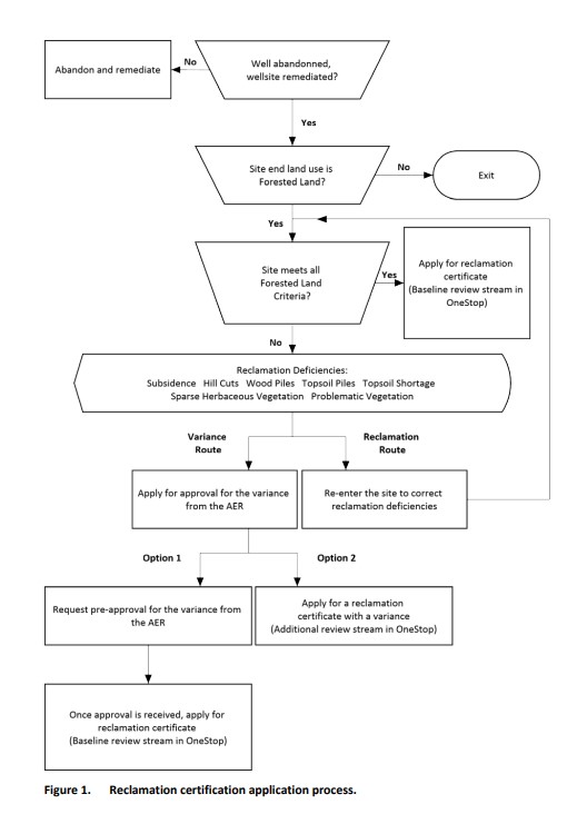
Preparing Variance Justifications for Reclamation Certification of Wellsites and Associated Facilities on Forested Land: 2023 Update
Resource
In 2021, PTAC sought verification of the Guide to Preparing Variance Justifications and stakeholders were asked to apply the document to current sites in their work portfolio.
PTAC Evaluation of Reclamation Practices on Forested Upland and Peatland Well Sites
Project
Contact
Organization:
In general, regulators expect that disturbed sites in the boreal forest will undergo complete reclamation (recontouring, soil replacement and revegetation) with the goal of returning the site to pre...

Recreational Trail Impacts on the Plant Communities of Castle and Castle Wildland Provincial Parks in Southern Alberta
Resource
I measured the effect of recreational trails on plant species richness, community composition, and the presence of exotic and rare species in the Castle Provincial Parks of Alberta, Canada, by...

Revegetation of Post-mined Land Using Directly Planted Native and Local Shrub Species
Resource
Hand collecting vegetative propagules from surrounding pre-mined land and directly planting these propagules on post-mined land may be the only method to successfully establish key shrub species

Seismic Line Impacts on Proximal Boreal Forest and Wetland Environments in Alberta
Resource
This resource is available on an external database and may require a paid subscription to access it. It is included on the CCLM to support our goal of capturing and sharing the breadth of all...

Shortening Fire Return Interval Predisposes West-Central Canadian Boreal Peatlands to More Rapid Vegetation Growth and Transition to Forest Cover
Resource
Climate change in northern latitudes is increasing the vulnerability of peatlands and the riparian transition zones between peatlands and upland forests (referred to as ecotones) to greater frequency...

Shrub Changes with Proximity to Anthropogenic Disturbance in Boreal Wetlands Determined Using Bi-temporal Airborne LiDAR in the Oil Sands Region, Alberta Canada
Resource
Bi-temporal LiDAR data used to identify correspondence between density of anthropogenic disturbances, wetland shape complexity and changes in vegetation height within >1800 wetlands near Fort McKay

SMART Remediation
Event
Event Date and Time
March 11th, 2020 at 8:30am MST to March 12th, 2020 at 2:40pm MST
, AB
Organization
Coordinated by Vertex Environmetal Inc., Smart Methods in Advanced Remediation Technologies (SMART) is a series of technical learning seminars for environmental professionals and designed to help...

SMART Remediation Seminars
News
Organization
Smart Methods in Advanced Remediation Technologies (SMART) is a series of technical learning seminars for environmental professionals. Our goal is to bring the North American environmental community...

Surface Soil Handling on Mines in the Boreal Forest – from Textbook to Operations
Resource
Research has shown forest surface soil provides an economical, diverse and abundant source of native propagules and an important source of nutrients and soil fauna. Salvage depth affects soil quality

The Biophysical Climate Mitigation Potential of Boreal Peatlands During the Growing Season
Resource
Peatlands and forests cover large areas of the boreal biome and are critical for global climate regulation. They also regulate regional climate through heat and water vapour exchange with the...
Theses - University of Lethbridge
Project
Organization:
Electronic theses from University of Lethbridge students.
Towards a Shared Foundation for Innovation and Evolution
Resource
At the 2023 Alberta Chapter, Canadian Land Reclamation Association annual conference, Chris Powter, Tanya Richens, Andy Etmanski, Amanda Schoonmaker, and Dean MacKenzie participated in a panel...
Tree Species Mapping Around Reclaimed Oil and Gas Wells Sites Using Hyperspectral and Light Detection and Ranging (LiDAR) Remote Sensing
Resource
Oil and gas activities in Alberta require disturbing forested lands, among other ecosystems, in order to extract resources. Due to the number of oil and gas sites requiring reclamation, monitoring can...

Video - A multi-level classification for Boreal wetlands
Resource
This presentation discusses the need for a multi-level classification for boreal wetlands and accurate change detection.

Video - Alberta Water Extent Monitoring Pilot Study
Resource
This presentation discusses the Alberta water extent monitoring pilot study, with the goal to create a database that has the potential for implementation at a provincial level.

Video - Bathymetric LiDARs for Hydrographic Mapping
Resource
This presentation talks about Bathymetric LiDARs for Hydrographic Mapping with a focus on ALTM systems and data fusion.

Video - Capture Sand in Flocculated Fines: A New Approach to optimize the Capture of Oil Sands Fines in Sand Beach
Resource
Ruijun Sun is a Senior Research Engineer with the Saskatchewan Research Council (SRC), Saskatoon, Saskatchewan. Ruijun Sun describes a new way to optimize the capture of oil sands clay fines in sand...
