
Search Results
Displaying:
21 - 40 of 62
Monitoring Procedures for Wellsite, In-Situ Oil Sands and Coal Mine Reclamation in Alberta – December 2014 Update
Resource
Scope of the project is to develop a geomatics-based monitoring system to support the Government of Alberta’s efforts for monitoring reclamation success. Software will support decision making process

Plow-in Pipeline Construction Improves Recovery of Rough Fescue Grassland
Resource
Plow-in pipeline approach resulted in a fescue-bluegrass vegetation community that had the best rough fescue recovery and greatest similarity to undisturbed natural grassland

Prioritization can Improve Cost Effectiveness of Seismic Line Restoration
Resource
Upland mesic sites showed a relatively strong ability to regenerate on their own (passive restoration), while lowland (bogs and fens) and upland dry sites were slow to recover.

Protecting Forest Floor in Place Rather than Stripping it Off is a Better Strategy to Regenerated Temporary Drilling Pads
Resource
Where forest floor was protected from disturbance, there were approximately 10 times as many aspen sprouts that were at least 3 times as tall as sprouts in the area where floor was stripped & replaced

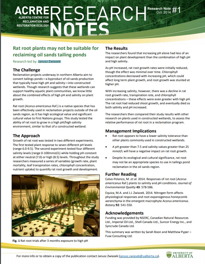
Rat Root Plants May Not be Suitable for Reclaiming Oil Sands Tailing Ponds
Resource
This study tested the ability of rat root to grow in a high pH/high salinity environment, similar to that of a constructed oil sands tailings pond wetland.
Reconstructed Soils in Alberta Oil Sands Limit Fine Root Growth of Trees
Resource
Tailings sand sites: fine root biomass decreased with depth and proximity to the textural interface. Overburden sites: fine root biomass decreased abruptly at the textural interface and EC increased

Recreational Trail Impacts on the Plant Communities of Castle and Castle Wildland Provincial Parks in Southern Alberta
Resource
I measured the effect of recreational trails on plant species richness, community composition, and the presence of exotic and rare species in the Castle Provincial Parks of Alberta, Canada, by...

Seismic Line Impacts on Proximal Boreal Forest and Wetland Environments in Alberta
Resource
This resource is available on an external database and may require a paid subscription to access it. It is included on the CCLM to support our goal of capturing and sharing the breadth of all...

Setting a Foundation for Indigenous Knowledge Systems-guided Boreal Caribou (tǫdzı) Conservation Planning in the Western Boreal Region of Canada: A Systematic Map Protocol
Resource
Abstract In recent years, researchers have increasingly recognized the need to bridge Western and Indigenous knowledge systems to strengthen research in wildlife conservation. Historically, this arena...

Shortening Fire Return Interval Predisposes West-Central Canadian Boreal Peatlands to More Rapid Vegetation Growth and Transition to Forest Cover
Resource
Climate change in northern latitudes is increasing the vulnerability of peatlands and the riparian transition zones between peatlands and upland forests (referred to as ecotones) to greater frequency...

Shrub Changes with Proximity to Anthropogenic Disturbance in Boreal Wetlands Determined Using Bi-temporal Airborne LiDAR in the Oil Sands Region, Alberta Canada
Resource
Bi-temporal LiDAR data used to identify correspondence between density of anthropogenic disturbances, wetland shape complexity and changes in vegetation height within >1800 wetlands near Fort McKay

Soil Salvage Depth is Key to Aspen Root Fragment Survival and Sucker Regeneration in Forest Reclamation
Resource
Aspen sucker production from root fragments was 3X higher at salvage/placement depth of 40 cm compared to 15 cm. Successful suckering occurred in root fragments with little damage in upper 20 cm soil

Temporary Drilling Pads From Oil Sands Exploration Require Microtopography for Restoration
Resource
Differences in microtopography were associated with differences in plant species richness and composition between OSE pads and the undisturbed sites.

The Biophysical Climate Mitigation Potential of Boreal Peatlands During the Growing Season
Resource
Peatlands and forests cover large areas of the boreal biome and are critical for global climate regulation. They also regulate regional climate through heat and water vapour exchange with the...
The Boreal-Arctic Wetland and Lake Dataset
Resource
Here we present the Boreal–Arctic Wetland and Lake Dataset (BAWLD), a land cover dataset based on an expert assessment, extrapolated using random forest modelling from available spatial datasets of...
Theses - Dalhousie University
Project
Organization:
DalSpace is a digital service that collects, preserves, and distributes digital material produced by the Dalhousie community.
Theses - University of Lethbridge
Project
Organization:
Electronic theses from University of Lethbridge students.
Tree Species Mapping Around Reclaimed Oil and Gas Wells Sites Using Hyperspectral and Light Detection and Ranging (LiDAR) Remote Sensing
Resource
Oil and gas activities in Alberta require disturbing forested lands, among other ecosystems, in order to extract resources. Due to the number of oil and gas sites requiring reclamation, monitoring can...
