
Search Results
Displaying:
61 - 80 of 418
Biomonitoring for the Effects of Air Pollution in the AOSERP Study Area. Report of a Workshop
Resource
Workshop to provide guidance to AOSERP concerning the establishment of a system to biologically monitor the effects of air pollution.

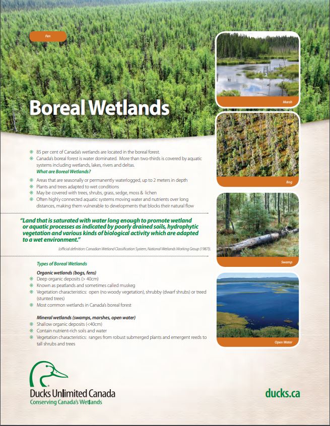
Boreal Wetland Factsheets
Resource
These fact sheets highlight plant, soil, and water indicators and key ecological benefits of each of the five major wetlands types.
Boreal Wetlands and Waterfowl: A Commitment to Stewardship Activities in Manitoba
Resource
Ducks Unlimited Canada (DUC) initiated the Western Boreal Program in 1997 with an understanding that working with forward thinking forest industry partners was key to advancing wetland conservation in...

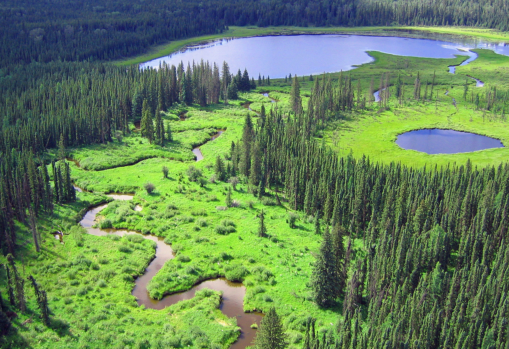
Boreal Wetlands of Canada and the United States of America
Resource
The Canadian and Alaskan boreal zone is one of the most water rich areas in the world, and contains an estimated combined surface water and peatland area the size of Indonesia (∼1.94 million km2)...
Breeding Distribution and Behaviour of the White Pelican in the Athabasca Oil Sands Area.
Resource
Aerial surveys and ground investigations were conducted in the spring and summer months from 1975 to 1977 on a breeding population of White Pelicans (Pelecanus erythrorhynchos) in the Birch Mountains

Building Better Crossings: Incorporating Wetland Knowledge into Road Planning and Construction
Resource
This research poster gives an overview of the relationship between roads and wetland flow, discusses tips and tools for planning and outlines a case study of developed crossings. Presented at the NAIT...

Canadian and American Indians: An Overview of Approaches to Research
Resource
Research concepts, methodologies and data collection instruments and procedures which are appropriate in white communities might not be so in Indian and Metis communities.

Canadian Fieldwork Applications
Resource
Did you know that you can learn to identify and report invasive species, measure trees, and become a citizen scientist all at the touch of your smartphone? Check out this list of free, Canadian field...

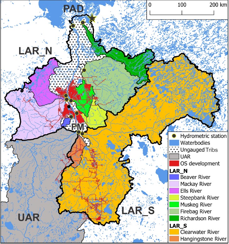
Changes in Geographical Runoff Generation in Regions Affected by Climate and Resource Development: A Case Study of the Athabasca River
Resource
The goal of this study is to enhance the understanding of the regional role of the lower Athabasca Basin areas in overall runoff delivery to the downstream Peace-Athabasca Delta. The Cold-regions...
Characterization of Organic Constituents in Waters and Wastewaters of the Athabasca Oil Sands Mining Area
Resource
Organic constituents of wastewaters discharged from the GCOS plant and Syncrude Canada Ltd. lease No. 17 were characterized and compared to those occurring naturally in the Athabasca River

Characterization of Stored Peat in the Alberta Oil Sands Area
Resource
Physical, chemical, and microbiological properties of stored materials were compared with those of fibric moss peat, mesic moss peat, and mesic fen peat samples from undisturbed sites

Circulation of Water and Sediment in the Athabasca Delta Area
Resource
Describe how water and sediment from the Athabasca River are distributed through the delta system and how they circulate and mix in Lake Athabasca and flow through to the Slave River (re contaminants)

Climatological Analysis of Recent Data from the Athabasca Oil Sands Area
Resource
Climatological analysis of recent data from the MAPS network of automatic meteorological data acquisition, forestry lookout stations, minisondes, pack surveys, and the Fort McMurray station

Community-level Modelling of Boreal Forest Mammal Distribution in an Oil Sands Landscape
Resource
This resource is available on an external database and may require a paid subscription to access it. It is included on the CCLM to support our goal of capturing and sharing the breadth of all...

Control of Small Mammals on Reclamation Areas in the AOSERP Study Area
Resource
Control rodent damage by: (1) Planting trees and shrubs when rodent numbers are at the low or declining phase of their cycle, and (2) Manipulating rodent numbers by manipulating vegetative cover.

Creating a Detailed Wetland Inventory with Sentinel-2 Time-Series Data and Google Earth Engine in the Prairie Pothole Region of Canada
Resource
Wetlands in the Prairie Pothole Region (PPR) of Canada and the United States represent a unique mapping challenge. They are dynamic both seasonally and year-to-year, are very small, and frequently...

Cumulative Effects and Boreal Woodland Caribou: How Bow-Tie Risk Analysis Addresses a Critical Issue in Canada's Forested Landscapes
Resource
Boreal caribou (Woodland Caribou, boreal population; Rangifer tarandus caribou) is a prominent mammal at the heart of a decades-long conflict between a growing resource sector and the associated risks...