
Search Results
Displaying:
1 - 20 of 25
Comparison of Soil Quality and Productivity of Reclaimed and Native Oil Sands Soils
Resource
The primary target of land reclamation in the Athabasca Oil Sands (AOS) region of Canada is to re-create ecosystems which are similar to the pre-disturbance ecosystems. The main objective of this...

Erasing Anthropogenic Disturbance: Natural Revegetation of Linear Features Following Wildfire, and the Implications for Woodland Caribou (Rangifer tarandus caribou) Habitat Management
Resource
The federal recovery strategy for woodland caribou identifies wildfires within the last 40 years and anthropogenic disturbance visible at a scale of 1:50,000, including a 500-m buffer, as disturbed...

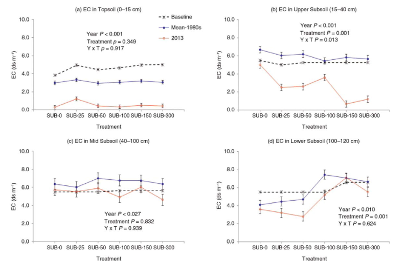
Long-term Changes in Soil Salinity as Influenced by Subsoil Thickness in a Reclaimed Coal Mine in East-central Alberta
Resource
Elevated salinity and sodicity are major challenges to reclamation of surface-mined coal sites in the Alberta Plains region. Research plots were established in 1981 at the Battle River Coal Mine near...
Podcast - Shift talks Sacred Science with Alvin First Rider, Brett Purdy, and Emily Herdman
Resource
Alvin First Rider speaks about his nation's use western science alongside Indigenous Knowledge to bring buffalo back to their historical plains.

Quantifying Restoration Success via Natural Recovery in Forested Areas Following Pipeline Construction
Resource
This resource is available on an external database and may require a paid subscription to access it. It is included on the CCLM to support our goal of capturing and sharing the breadth of all...

Using LiDAR, Colour Infrared Imagery, and Ground Truth Data for Mapping and Characterizing Vegetation Succession on Disturbance Types: Implications for Woodland Caribou (Rangifer tarandus caribou) Habitat Management
Resource
Woodland caribou (Rangifer tarandus caribou) occur throughout Canada’s boreal forest and have been declining both in distribution and population size along the southern extent of their range...
Vegetation Recovery on Low Impact Seismic Lines in Alberta's Oil Sands and Visual Obstruction of Wolves (Canis lupus) and Woodland Caribou (Rangifer tarandus caribou)
Resource
Low-Impact Seismic (LIS) exploration techniques are being increasingly used in northeastern Alberta, Canada to explore for in-situ oil sands deposits. These narrow (2-4-m wide), meandering man-made...
Video - Assessing Cumulative Ecological Effects: The Changing Management Landscape
Resource
Jim Schieck discusses how cumulative effects are currently being assessed in Alberta.

Video - Assessment of forest attributes using airborne and terrestrial LiDAR
Resource
This presentation discusses the different ways that LiDAR data can be effectively used in forestry management applications.

Video - Blood Tribe Buffalo Restoration Project
Resource
Members of the Káínawa – or Blood Tribe – are applying training in western science, alongside their Indigenous Knowledge, to bring buffalo back to their historical habitat in southern Alberta, the...

Video - Building a Sustainable Alberta Through Deployment of LiDAR Technologies: Reflections from an SRD perspective
Resource
Barry White discusses the ways LiDAR is being used by departments within the government of Alberta.

Video - Caribou Conservation Project
Resource
The Denesųłiné of Cold Lake First Nations (CLFN) are applying both their Indigenous Knowledge and expertise in western science to develop and implement diverse caribou conservation strategies in...

Video - Enhanced Fuel Mapping for Wildfire Management
Resource
This presentation discusses ways that LiDAR data can be used in forestry management, including for mapping mountain pine beetle infestations.

Video - Feature Extraction from Multisensor Airborne Data: Monitoring of large-scaled industrial activity on the natural landscape
Resource
This presentation discusses using airborne LiDAR data on monitoring projects with the federal and provincial government. Data collection and data extraction are reviewed.

Video - From Point Cloud to Supporting Decisions: Making use of your LiDAR data
Resource
This presentation discusses how to use LiDAR data, in particular for forestry, but also for other government and industry applications.

Video - High Resolution Inventories Using LiDAR: Challenges and opportunities
Resource
This presentation discuss a pilot project done with Spray Lakes Sawmill FMA related to doing plot inventories using LiDAR.

Video - LiDAR Data Capture and Analysis Standards
Resource
This presentation discusses some of the issues with data collection and analysis that could lead users to require standards.

Video - LiDAR: Demonstrating value to Alberta Parks through 101 uses
Resource
This presentation discusses how Alberta Parks uses LiDAR data to inform decision-making in their land management activities.
