
Search Results
Displaying:
1 - 20 of 67
Alberta Watercourse Crossing Collaborative Fall 2021 Webinar Series
Resource
The Alberta Watercourse Crossing Collaborative held a Fall 2021 Webinar Series to fulfill its objectives around information transfer, education and training. Webinars included: Alberta Watercourse...
Alberta Wetland Classification System
Resource
The Alberta Wetland Classification System (AWCS) incorporates and merges information from existing wetland classification systems to provide a holistic classification system for the province. The AWCS...

Amphibians and Reptiles in the AOSERP Study Area
Resource
Wood frog (Rana sylvatica) was the most abundant and widespread species in 20 sites examined. Boreal chorus frogs (Pseudacris triseriata maculata) and Canadian toads (Bufohemiophrys) found at

Canadian Wetland Inventory using Google Earth Engine: The First Map and Preliminary Results
Resource
Although wetlands provide valuable services to humans and the environment and cover a large portion of Canada, there is currently no Canada-wide wetland inventory based on the specifications defined...

Chapter 18 - Creative Approaches in Engaging the Community Toward Ecological Waste Management and Wetland Conservation
Resource
This resource is available on an external database and may require a paid subscription to access it. It is included on the CCLM to support our goal of capturing and sharing the breadth of all...

Code of Practice for Wetland Replacement Works
Resource
This code of practice regulates wetland restoration and wetland construction activities as defined in the Code by replacing Water Act approval requirements. Wetland restoration is applied to wetlands...

Comparing Deep Learning and Shallow Learning for Large-Scale Wetland Classification in Alberta, Canada
Resource
Developed two wetland inventory style products for a large (397,958 km2) area in the Boreal Forest region of Alberta, Canada, using Sentinel-1, Sentinel-2, and ALOS DEM data

Drivers, Pressures, and State Responses to Inform Long-term Oil Sands Wetland Monitoring Program Objectives
Resource
Boreal peatlands provide numerous ecosystem services ranging from carbon sequestration to the provisioning of habitat for species integral to Indigenous communities. In the Oil Sands Region of Alberta...
Estimate of the Maximum Probable Precipitation for Alberta River Basins
Resource
Point measurements of maximum depth showed that over 50% of the rainstorms occur in June and July, with only a small percentage in April (5.6) and September (10. 1).

Estimating Lichen Biomass in Forests and Peatlands of Northwestern Canada in a Changing Climate
Resource
Climate warming in the North could lead to lichen decline within critical woodland caribou habitat. We used repeat measurements of sixty-nine plots over ten years (2007–2008 and 2017–2018) to assess...
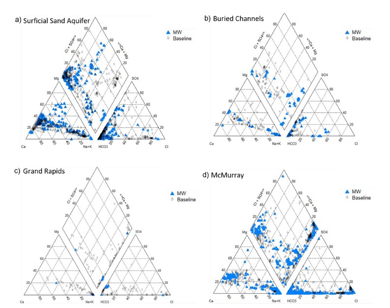
Groundwater Monitoring Near Oil Sands Development: Insights From Regional Water Quality Datasets in the Alberta Oil Sands Region (AOSR)
Resource
Groundwater quality data for the AOSR are compiled and interpreted to provide information on regional water quality to inform groundwater monitoring and land use planning. A database of 546 water...

Groundwater Monitoring Near Oil Sands Development: Insights from Regional Water Quality Datasets in the Alberta Oil Sands Region (AOSR)
Resource
Groundwater quality data for the AOSR are compiled and interpreted to provide information on regional water quality to inform groundwater monitoring and land use planning. A database of 546 water...
Guide to Ecological Sites of the Upper Boreal Highlands Subregion
Resource
The Upper Boreal Highlands subregion is found elevationally above the Lower Boreal Highlands subregion in the Birch Mountain, Buffalo Head Hills and Cameron Hills of Northcentral and Northwestern...

Guide to Watershed Management Planning In Alberta
Resource
The Guide to Watershed Management Planning in Alberta provides advice on the steps to develop and implement a watershed management plan.
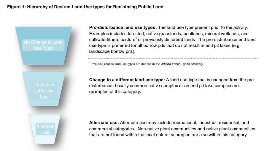
Guidelines for End Land Use Planning for Reclaiming Borrow Pits Supporting Energy Activities on Public Lands
Resource
A primary goal of this Guideline is to emphasize the long-standing preference for reclaiming and restoring public lands to the pre-disturbance land use type.
Interim Report on a Soils Inventory in the Athabasca Oil Sands Area 1978
Resource
The emphasis in this inventory is on soils and the landforms on which they occur; both are indicated on maps. Air photo interpretation and field checking have been completed

Low Extent but High Impact of Human Land Use on Wetland Flora Across the Boreal Oil Sands Region
Resource
Boreal wetlands are at risk of degradation from anthropogenic activities including oil sands energy extraction. Despite efforts to monitor the impacts of oil sands energy extraction-related activities...
