
Search Results
Displaying:
1 - 20 of 24
Big Backyard BioBlitz
Event
Event Date and Time
July 29th, 2021 at 12:00am to August 2nd, 2021 at 11:59pm
Organization
New to citizen science? It doesn’t take much. Grab your smartphone, tablet or camera, head outside to search for plants, animals and insects, snap a photo and share. From urban centres to remote...
Conservation Close to Home - Story Map
Resource
Conservation Assessment for Southern Canada The Nature Conservancy of Canada (NCC) has completed a comprehensive assessment of the conservation needs and opportunities in southern Canada. The first of...

Impacts of Climate and Catastrophic Forest Changes on Streamflow and Water Balance in a Mountainous Headwater Stream in Southern Alberta
Resource
Rivers in Southern Alberta are vulnerable to climate change because much of the river water originates as snow in the eastern slopes of the Rocky Mountains.

Large Stocks of Peatland Carbon and Nitrogen are Vulnerable to Permafrost Thaw
Resource
Northern peatlands have accumulated large stocks of organic carbon (C) and nitrogen (N), but their spatial distribution and vulnerability to climate warming remain uncertain. Here, we used machine...

Modeled Production, Oxidation, and Transport Processes of Wetland Methane Emissions in Temperate, Boreal, and Arctic Regions
Resource
This resource is available on an external database and may require a paid subscription to access it. It is included on the CCLM to support our goal of capturing and sharing the breadth of all...
NatureTalks: Wetlands 101
Event
Event Date and Time
March 29th, 2022 at 6:00pm MST to March 29th, 2022 at 7:00pm MST
Organization
What is a wetland? Do you know how to spot one? Did you know that the health of wetlands and grasslands are connected? Wetlands aren’t simply beautiful features of a landscape; they are important to...
Proceedings of a Workshop to Develop a Strategic Plan for a Watershed Assessment Model (WAM)
Resource
Report of proceedings from a workshop to produce a strategic plan for developing a Watershed Assessment Model and identifying key project events.
The Outaouais Regions Frogs and their Role in Saving Wetland: Nature conservancy of Canada Webinar
Event
Event Date and Time
August 19th, 2021 at 1:00pm EST to August 19th, 2021 at 2:00pm EST
, QC
Organization
On Thursday, August 19 from 1 - 2 p.m. ET, a conservation biologist from the Nature Conservancy of Canada (NCC) will talk about the Outaouais region's frogs and their crucial role in saving our...
Vegetation Growth on Seismic Lines in West-Central and North-Western Alberta
Resource
Seismic lines are slow to recover naturally, and many seismic lines need to be restored to contribute towards caribou recovery. Caribou predators use seismic lines to travel throughout caribou ranges...

Video - A Drainage Network Model for Regional-scale Land-use Planning in Alberta's Foothills
Resource
Dr. Richard McCleary draws the links between what we see in the field to the maps we have for planning and points out that the information we need for watershed assessment and riparian zones is the same.

Video - Adaptive Management and Native Fish Conservation Planning
Resource
Dr. Lorin Hicks talks about the Montana example of habitat conservation planning in forestry management.

Video - Alberta's Watershed Management Symposium: Flood and Drought Mitigation
Resource
This public symposium covers Alberta's progress to improve its flood and drought resiliency, including the role of natural solutions. NOTE: This is a 4 hour video with multiple presenters
Video - Can Wet Areas Mapping Data Contribute to Riparian Management?
Resource
Dr. Barry White reviews the progress made with LiDAR and wet area mapping in Alberta.

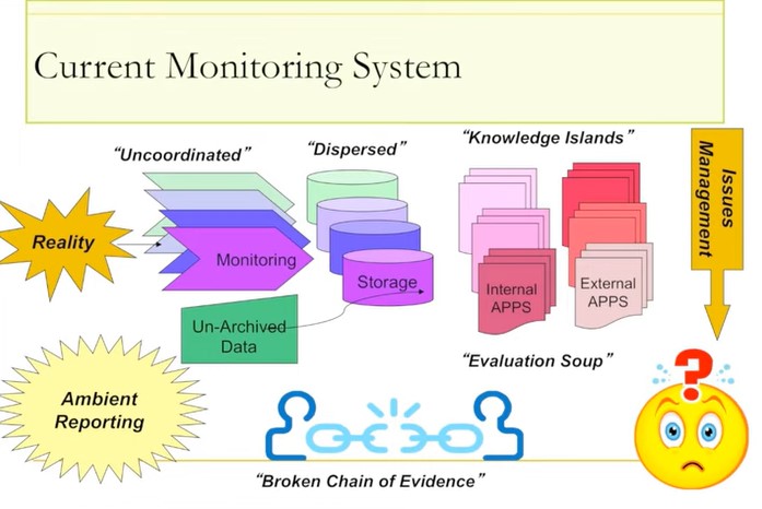
Video - Raising the Bar: Development of a World Class Environmental Monitoring System for Alberta
Resource
Ernie Hui gave a keynote address at the CWRA-WPAC joint conference on March 13, 2013. Ernie Hui is the CEO, Environmental Monitoring, for Alberta Environment and Sustainable Resource Development. The...
Video - Riparian Digital Mapping Using Ecological Boundaries in West-central Alberta
Resource
Dr.Rick Bonar describes how riparian mapping is used to define riparian ecological areas and the management strategy for those areas.

Video - Riparian Management in Alberta's Forests: Where we are - Where we are Going
Resource
ohn Stadt, Alberta Environment and Sustainable Resource Development, describes forestry management policy in Alberta specifically in regards to riparian zones in forests.

Video - Riparian Vegetation: Identifying Boundaries and Quantifying Structure using LiDAR
Resource
Jay Mills, Vegetation Data Specialist with Jeodesy GIS, talks about LiDAR data and interpreting it for riparian vegetation.
