Wetlands Knowledge Search Results
Resource
Authors
Alberta Biodiversity Monitoring Institute
As of 2015, 29.2% of Alberta is under human footprint, up from 25.7% in 1999—that’s an average increase of about 0.22%, or around 1450 km2 (560 sections) per year.
Resource
Authors
Mir Mustafizur Rahman
Gregory McDermid
Maria Strack
Julie Lovitt
Resource Date:
October
2017
Groundwater level (GWL) and depth to water (DTW) are related metrics aimed at characterizing groundwater-table positions in peatlands, and two of the most common variables collected by researchers...
Resource
Authors
Daphne Cheel
Stephen Moran
Mark Trudell
Don Thacker
Terry Macyk
Report synthesizes and summarizes 36 RRTAC reports to provide the user with a unified source of information on land and groundwater reclamation research in the plains of Alberta
Resource
Authors
Aaron Sekerak
Gordon Walder
Maps showing fish collection locations, photos and details of the physical characteristics of nine streams within five watersheds (Firebag, Muskeg, Steepbank, MacKay, and Ells) in AOSERP study area
Resource
During 1978, a number of aquatic projects were funded by AOSERP using a habitat inventory and mapping approach.
Resource
Authors
M.S. Thompson
J. Crosby-Diewold
Relationship between aquatic macrophyte growth and habitat factors found in the AOSERP study area is outlined, as are some implications of aquatic macrophyte inventory for management and revegetation
Resource
Authors
Alberta Biodiversity Monitoring Institute
We’re pleased to announce the release of the ABMI Alberta-wide Wetland Inventory—our most up-to-date and high-resolution wetland data yet.
Resource
A resource to improve understanding of wetlands in the Bow River region to promote conservation through protection and restoration. Wetlands are natural assets that have a vital role in climate change...
Resource
Authors
Evan DeLancey
John Simms
Masoud Mahdianpari
Brian Brisco
Craig Mahoney
Jahan Kariyeva
Developed two wetland inventory style products for a large (397,958 km2) area in the Boreal Forest region of Alberta, Canada, using Sentinel-1, Sentinel-2, and ALOS DEM data
Resource
Authors
Lauren Thompson
M. Low
C. Schulze
M. Simba
R. Shewan
O. Sonnentag
S.E. Tank
D. Olefeldt
Boreal rivers deliver dissolved organic carbon (DOC), mercury (Hg), and its neurotoxic form, methylmercury (MeHg), from contributing landscapes to downstream waters. In northern regions, thawing...
Resource
Authors
Evan DeLancey
Agatha Czekajlo
Lyle Boychuk
Fiona Gregory
Meisam Amani
Brian Brisco
Jahan Kariyeva
Jennifer Hird
Wetlands in the Prairie Pothole Region (PPR) of Canada and the United States represent a unique mapping challenge. They are dynamic both seasonally and year-to-year, are very small, and frequently...
Resource
Authors
Jason Clark
Ken Tape
Latha Baskaran
Clayton Elder
Charles Miller
Kimberley Miner
Jonathan O'Donnell
Benjamin Jones
Beaver engineering in the Arctic tundra induces hydrologic and geomorphic changes that are favorable to methane (CH 4) production. Beaver-mediated methane emissions are driven by inundation of...
Resource
Resource Date:
January
2016
This presentation provides an overview of the Ducks Unlimited Canada Enhanced Wetland Classification System, including current and potential uses for wetland conservation and management.
Resource
Authors
Roger DeAbreu
Shane Patterson
Todd Shipman
Chris Powter
NRCan pilot science projects have proven that Earth Observation can provide relevant and valuable information to inform and enhance monitoring and support regulatory frameworks
Resource
Authors
Xiaoyu Li
Julie Talbot
James King
Meng Wang
Resource Date:
October
2023
Dust deposition can fertilize nutrient-limited peatlands and affect their plant assemblages and ecosystem functions, but the effects of local road dust on peatlands have seldom been studied. Here, we...
Resource
Authors
Camille Defrenne
Jessica Moore
Colin Tucker
Louis Lamit
Evan Kane
Randall Kolka
Rodney Chimner
Jason Keller
Erik Lilleskov
Drainage-induced encroachment by trees may have major effects on the carbon balance of northern peatlands, and responses of microbial communities are likely to play a central mechanistic role. We...
Resource
Authors
Stephen Moran
Terry Macyk
Mark Trudell
Margot Pigot
In 1985, a one hectare pond developed in the upland reclaimed landscape at Vesta Mine in an area where extensive ponding had not previously been observed. Because of the thickness of the spoil, about...
Resource
Authors
Stephen Moran
Mark Trudell
Terry Macyk
Daphne Cheel
The first phase of the study, which was completed in 1984, included characterization and instrumentation of two study areas: the Battle River study area, which included Diplomat, Vesta and Paintearth...
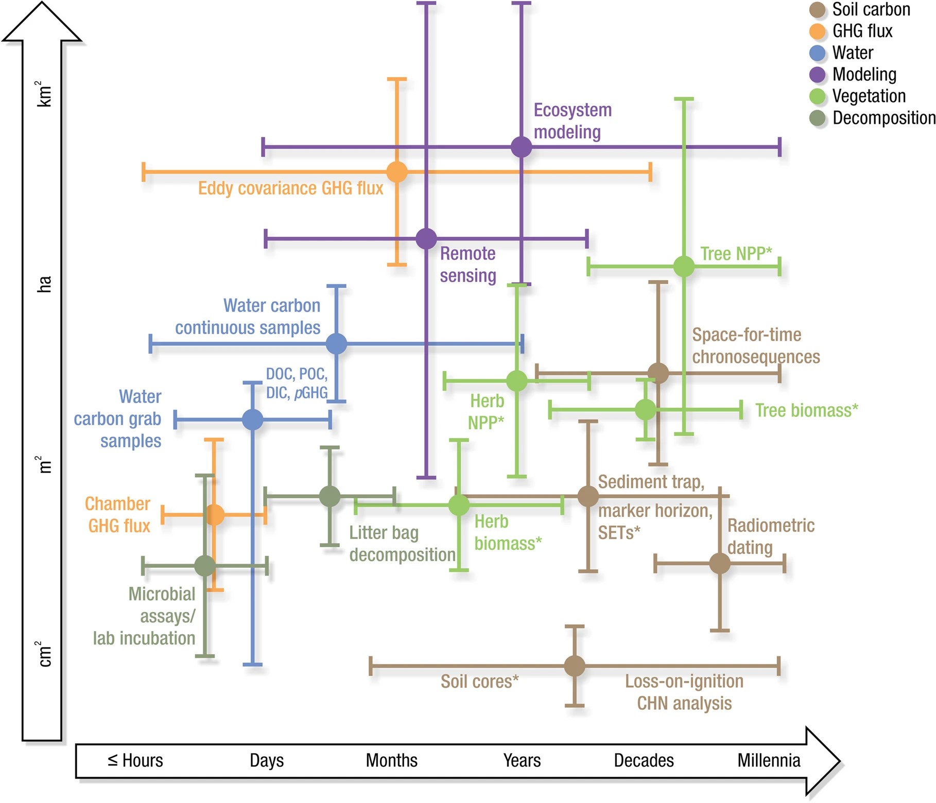
Resource
Authors
Sheel Bansal
Irena Creed
Brian Tangen
Scott Bridgham
Ankur Desai
Ken Krauss
Scott Neubauer
Gregory Noe
Donald Rosenberry
Carl Trettin
Kimberly Wickland
Scott Allen
Ariane Arias‑Ortiz
Anna Armitage
Dennis Baldocchi
Kakoli Banerjee
David Bastviken
Peter Berg
Matthew Bogard
Alex Chow
William Conner
Christopher Craft
Courtney Creamer
Tonya DelSontro
Jamie Duberstein
Meagan Eagle
Siobhan Fennessy
Sarah Finkelstein
Mathias Göckede
Sabine Grunwald
Meghan Halabisky
Ellen Herbert
Mohammad Jahangir
Olivia Johnson
Miriam Jones
Jefrey Kelleway
Sara Knox
Kevin Kroeger
Kevin Kuehn
David Lobb
Amanda Loder
Shizhou Ma
Damien Maher
Gavin McNicol
Jacob Meier
Beth Middleton
Christopher Mills
Purbasha Mistry
Abhijit Mitra
Courtney Mobilian
Charles Schutte
Changchun Song
Camille Stagg
Jessica Turner
Rodrigo Vargas
Mark Waldrop
Marcus Wallin
Zhaohui Aleck Wang
Eric Ward
Debra Willard
Stephanie Yarwood
Xiaoyan Zhu
Wetlands cover a small portion of the world, but have disproportionate influence on global carbon (C) sequestration, carbon dioxide and methane emissions, and aquatic C fluxes. However, the underlying...
Resource
Authors
A. Brown
M.J. Kent
J.O. Park
R.D. Roberts
3 aspects of aquatic habitat assessment and mapping. 1 - review of the parameters which characterize aquatic habitats. 2 - efficient procedure for collecting the data. 3 - computer mapping techniques