Land Management Search Results
Resource
Objective - develop a collective understanding of the scope of sites impacted by soil sterilants (bromacil and tebuthiuron) and the specific challenges associated with their remediation and management
Resource
Authors
National Tree Seed Centre
Resource Date:
April
2022
Session one of the Scaling Up Seed Supply webinar series presented by the National Tree Seed Centre. This session focuses on the equipment needed to collect, clean, and store tree and shrub seeds...
Resource
Authors
National Tree Seed Centre
This webinar presented by the National Tree Seed Centre focuses on tree and shrub species that produce seed in the autumn and how to predict if they will produce a good seed crop. Species discussed...
Resource
Authors
National Tree Seed Centre
This webinar presented by the National Tree Seed Centre explains how to collect seeds from berry producing plants species. NTSC staff demonstrate protocols for handling and processing berries to...
Resource
Authors
National Tree Seed Centre
Resource Date:
April
2022
This webinar presented by the National Tree Seed Centre focuses on tree and shrub species at risk and how to properly and effectively collect and store their seeds for maximum reforestation potential...
Resource
Authors
National Tree Seed Centre
This webinar presented by the National Tree Seed Centre teaches the skills and practices needed for collecting seeds from tree species which produce seeds in the spring. NTSC staff discuss maples...
Resource
Authors
Alvin First Rider
Emily Herdman
Brett Purdy
Alvin First Rider speaks about his nation's use western science alongside Indigenous Knowledge to bring buffalo back to their historical plains.
Resource
This presentation describes a method of assessing cumulative effects, taking into account the many drivers or pressures on the landscape and their effects on watershed processes.
Resource
As a consequence of climate change, current landscape patterns are unlikely to persist in the future. The types of ecological changes expected to occur as the climate warms are described
Resource
Resource Date:
March
2013
This presentation describes how the Alberta oil and gas industry decided to go with a oil/gas spill cooperative rather than having individual company spill response units.
Resource
This presentation was a part of the Petroleum Technology Alliance of Canada, Hydraulic Fracturing in Western Canada: an Environmental Perspective Forum, in May of 2014.
Resource
This presentation provides an example oaf how Wet Areas Mapping and LiDAR can be used as a tool to monitor biodiversity.
Resource
Authors
Alvin First Rider
Justin Bruised head
Truman Big Swallow
Jamison Lucas Russell
Members of the Káínawa – or Blood Tribe – are applying training in western science, alongside their Indigenous Knowledge, to bring buffalo back to their historical habitat in southern Alberta, the...
Resource
Resource Date:
March
2012
Barry White discusses the ways LiDAR is being used by departments within the government of Alberta.
Resource
Bruce Peachey, president of New Paradigm Engineering Ltd, discusses the complexities of hydraulic fracturing in Alberta.
Resource
Susan Stuver, Research Scientist for Texas A&M Institute of Renewable Natural Resources, discusses the development of advanced analytical methods for open path systems
Resource
I will demonstrate how data from ABMI can be combined with designed research studies to answer questions at spatial scales and temporal extents that are not possible for a single researcher to achieve
Resource
Authors
Shannon White
Jim Herbers
Jasmine Janes
Sarah Depoe
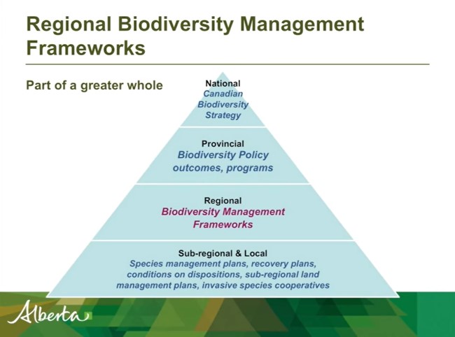
Shannon R. White is the Biodiversity Specialist for the Land-use Framework Regional Planning Branch for ESRD. She discusses Biodiversity Management Frameworks (BMFs), including indicators, triggers...
Resource
Resource Date:
March
2012
Jae Ogilvie presents on his group's research related to the use of Wet Areas Mapping data to predict the flow of contaminants from the Rainbow pipeline spill in northern Alberta in 2011.
Resource
Authors
Brian Sawyer
Phil Mackenzie
Resource Date:
March
2012
Brian Sawyer and Phil Mackenzie discuss how GOA decided to acquire LiDAR data, the value it has to various government departments, and how it is being used.