Wetland Knowledge Resources
Resource
Author(s)
Sheel Bansal
Irena Creed
Brian Tangen
Scott Bridgham
Ankur Desai
Ken Krauss
Scott Neubauer
Gregory Noe
Donald Rosenberry
Carl Trettin
Kimberly Wickland
Scott Allen
Ariane Arias-Ortiz
Anna Armitage
Dennis Baldocchi
Kakoli Banerjee
David Bastviken
Peter Berg
Matthew Bogard
Alex Chow
William Conner
Christopher Craft
Courtney Creamer
Tonya DelSontro
Jamie Duberstein
Meagan Eagle
Siobhan Fennessy
Sarah Finkelstein
Mathias Göckede
Sabine Grunwald
Meghan Halabisky
Ellen Herbert
Mohammad Jahangir
Olivia Johnson
Miriam Jones
Jefrey Kelleway
Sara Knox
Kevin Kroeger
Kevin Kuehn
David Lobb
Amanda Loder
Shizhou Ma
Damien Maher
Gavin McNicol
Jacob Meier
Beth Middleton
Christopher Mills
Purbasha Mistry
Abhijit Mitra
Courtney Mobilian
Charles Schutte
Changchun Song
Camille Stagg
Jessica Turner
Rodrigo Vargas
Mark Waldrop
Marcus Wallin
Zhaohui Aleck Wang
Eric Ward
Debra Willard
Stephanie Yarwood
Xiaoyan Zhu
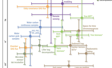
Wetlands cover a small portion of the world, but have disproportionate influence on global carbon (C) sequestration, carbon dioxide and methane emissions, and aquatic C fluxes. However, the underlying...
Resource
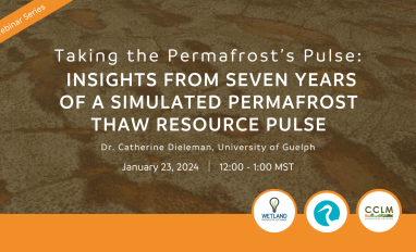
Taking the permafrost’s pulse – Insights from seven years of a simulated permafrost thaw resource pulse. Dr. Catherine Dieleman, University of Guelph Northern peatland soils are important long-term...
Resource
The Wetland Knowledge Exchange releases monthly newsletters that highlight new research, publications, news, events and more. In this edition you will learn about: Predicting increases in mercury and...
Resource
Author(s)
Humaira Enayetullah
Laura Chasmer
Chris Hopkinson
Daniel Thompson
Danielle Cobbaert
Seismic lines are the dominant anthropogenic disturbance in the boreal forest of the Canadian province of Alberta, fragmenting over 1900 km 2 of peatland areas and accounting for more than 80% of all...
Resource
Author(s)
Lauren Thompson
M. Low
Renae Shewan
Christopher Schulze
M. Simba
Oliver Sonnentag
Suzanne Tank
David Olefeldt
Boreal rivers deliver dissolved organic carbon (DOC), mercury (Hg), and its neurotoxic form, methylmercury (MeHg), from contributing landscapes to downstream waters. In northern regions, thawing...
Resource
Author(s)
Naomi Gatis
Pia Benaud
Karen Anderson
Josie Ashe
Emilie Grand-Clement
David Luscombe
Alan Puttock
Richard Brazier
Peatland restoration is experiencing a global upsurge as a tool to protect and provide various ecosystem services. As the range of peatland types being restored diversifies, do previous findings...
Resource
Author(s)
Stephanie Bascu
Christopher Spence
Wetlands that occupy topographic depressions are a defining feature of the Canadian Prairie. These features control hydrological connectivity as they contain high storage capacity relative to...
Resource
Author(s)
Nirmela Govinda
Peter Groffman
Sarah Durand
Chester Zarnoch
Willis Elkins
Denitrification, the anaerobic microbial conversion of nitrate (NO 3 −), a common water pollutant, to nitrogen (N) gases, is often high in the soil of natural wetlands. In areas where natural wetlands...
Resource
The resource link will access Part 1 of this presentation. Part 2 can be accessed here. John Pomeroy, professor at the University of Saskatchewan, talks about water supply resilience and flood risk...
Resource
This 2016 talk provides an overview of some of the issues related to groundwater in Alberta.