
Search Results
Displaying:
1 - 17 of 17
Alberta Mine Reclamation and Abandonment Requirements
Resource
Paper reviews ERCB processes for mine regulation, Board decisions relating to reclamation and abandonment, and new regulations for tailings at oil sands mining operations.

Alberta Watercourse Crossing Collaborative Fall 2021 Webinar Series
Resource
The Alberta Watercourse Crossing Collaborative held a Fall 2021 Webinar Series to fulfill its objectives around information transfer, education and training. Webinars included: Alberta Watercourse...
Community-level Modelling of Boreal Forest Mammal Distribution in an Oil Sands Landscape
Resource
This resource is available on an external database and may require a paid subscription to access it. It is included on the CCLM to support our goal of capturing and sharing the breadth of all...

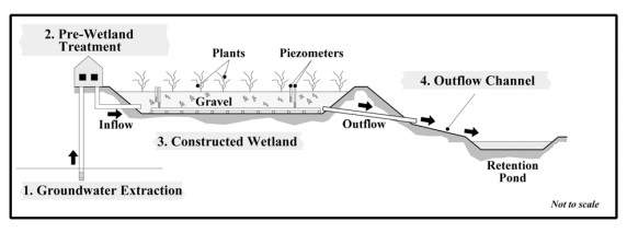
Constructed Wetland Pilot Project at the Strachan Gas Plant
Resource
A pilot scale constructed wetland was built at the Strachan Gas Plant to evaluate its ability to treat dissolved phase hydrocarbons in groundwater. The overall objective was to assess the feasibility...
Disturbance Zones of Influence on Boreal Songbird Communities in Northeastern Alberta
Resource
Canada’s boreal forest is important habitat for many North American birds, which play a vital role in the health of forests, and provide ecosystem services. Expanding human development in northern...

Invitation for Feedback on Revisions to Alberta Energy Regulator Directive 050
News
Organization
The Alberta Energy Regulator is seeking feedback on updates to Directive 050: Drilling Waste Management. The proposed changes reduce the regulatory burden throughout the life cycle of drilling waste...
Linear Features, Forestry and Wolf Predation of Caribou and Other Prey in West Central Alberta
Resource
The primary goal of this research was to determine how human activities affect caribou population dynamics through modification of predator‐prey relationships. This knowledge can then be used to...
Managing Regional Cumulative Effects of Oil Sands Development in Alberta, Canada
Resource
This resource is available on an external database and may require a paid subscription to access it. It is included on the CCLM to support our goal of capturing and sharing the breadth of all...

Review of Revegetation Practices for Oil and Gas Disturbances in Western Canada
Resource
Various methods have been developed and used to revegetate sites disturbed by oil and gas activities in Western Canada. Considerable information describing these methods and their effectiveness exists...
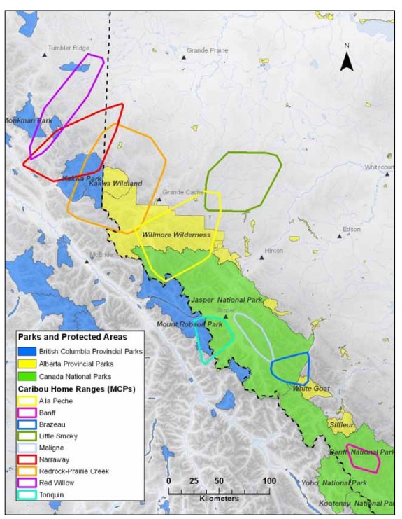
Scaling Up the Role of Predation in Caribou Declines in West-Central Alberta (Redwillow, Narraway, Redrock Prairie Creek, A la Pêche and Little Smoky Ranges)
Resource
Anthropogenic disturbances contribute to the way animals perceive and respond to their environment. These multiple disturbances can additionally act in non-independent ways to shape an animal’s...

Scaling Up the Role of Predation in Caribou Declines in West-Central Alberta (Redwillow, Narraway, Redrock Prairie Creek, A la Pêche and Little Smoky Ranges). 2012 AUPRF project status update
Resource
Avoidance by caribou and increased wolf predation risk in disturbed areas indicate functional habitat loss for caribou, yet these patterns alone do not necessarily imply a demographic impact. Spatial...

Scaling Up the Role of Predation in Caribou Declines in West‐Central Alberta (Redwillow, Narraway, Redrock Prairie Creek, A la Pêche and Little Smoky Ranges). Interim Report
Resource
Our primary goal is to address the relative contributions of forestry and oil and gas production to the decline of caribou populations. This knowledge can then be used to develop appropriate...

The Alberta Oil Sands
Resource
Overview of the oil sands, current commercial developments, experimental work, an overview of Fort McMurray and the role of government agencies in development and management of oil sands.

The Third Generation of Pan-Canadian Wetland Map at 10 m Resolution Using Multisource Earth Observation Data on Cloud Computing Platform
Resource
Development of the Canadian Wetland Inventory Map (CWIM) has thus far proceeded over two generations, reporting the extent and location of bog, fen, swamp, marsh, and water wetlands across the country...

Video - Surficial geology mapping in northern Alberta using LiDAR
Resource
This presentation describes the ways that LiDAR has helped some of the challenges previously encountered in data collection for the surficial geology mapping program.

Webinar - AER OneStop Record of Site Condition (RoSC) Information Update
Event
Event Date and Time
October 11th, 2023 at 10:00am MST to October 11th, 2023 at 11:30am MST
Organization
As part of AERs ongoing engagement activities, this is a live online session delivered through Microsoft Teams that will focus on RoSC submissions under the Contamination Review for Reclamation (CRR)...