
Search Results
Displaying:
1 - 20 of 32
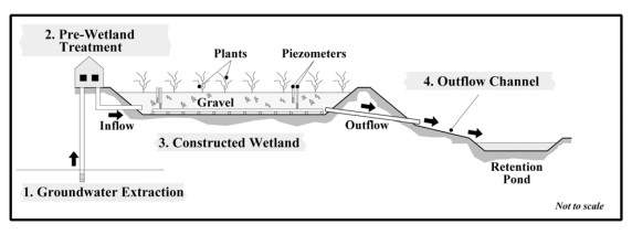
Constructed Wetland Pilot Project at the Strachan Gas Plant
Resource
A pilot scale constructed wetland was built at the Strachan Gas Plant to evaluate its ability to treat dissolved phase hydrocarbons in groundwater. The overall objective was to assess the feasibility...
Disturbance Zones of Influence on Boreal Songbird Communities in Northeastern Alberta
Resource
Canada’s boreal forest is important habitat for many North American birds, which play a vital role in the health of forests, and provide ecosystem services. Expanding human development in northern...

Linear Features, Forestry and Wolf Predation of Caribou and Other Prey in West Central Alberta
Resource
The primary goal of this research was to determine how human activities affect caribou population dynamics through modification of predator‐prey relationships. This knowledge can then be used to...
Podcast - Shift talks Sacred Science with Alvin First Rider, Brett Purdy, and Emily Herdman
Resource
Alvin First Rider speaks about his nation's use western science alongside Indigenous Knowledge to bring buffalo back to their historical plains.

Review of Revegetation Practices for Oil and Gas Disturbances in Western Canada
Resource
Various methods have been developed and used to revegetate sites disturbed by oil and gas activities in Western Canada. Considerable information describing these methods and their effectiveness exists...
Sacred Science Video Series
Project
Organization:
Bringing together Indigenous knowledge and western science creates opportunities for new solutions to environmental challenges, including issues that are important to Indigenous People. The Sacred...
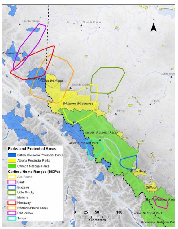
Scaling Up the Role of Predation in Caribou Declines in West-Central Alberta (Redwillow, Narraway, Redrock Prairie Creek, A la Pêche and Little Smoky Ranges)
Resource
Anthropogenic disturbances contribute to the way animals perceive and respond to their environment. These multiple disturbances can additionally act in non-independent ways to shape an animal’s...

Scaling Up the Role of Predation in Caribou Declines in West-Central Alberta (Redwillow, Narraway, Redrock Prairie Creek, A la Pêche and Little Smoky Ranges). 2012 AUPRF project status update
Resource
Avoidance by caribou and increased wolf predation risk in disturbed areas indicate functional habitat loss for caribou, yet these patterns alone do not necessarily imply a demographic impact. Spatial...

Scaling Up the Role of Predation in Caribou Declines in West‐Central Alberta (Redwillow, Narraway, Redrock Prairie Creek, A la Pêche and Little Smoky Ranges). Interim Report
Resource
Our primary goal is to address the relative contributions of forestry and oil and gas production to the decline of caribou populations. This knowledge can then be used to develop appropriate...

Video - Assessing Cumulative Ecological Effects: The Changing Management Landscape
Resource
Jim Schieck discusses how cumulative effects are currently being assessed in Alberta.

Video - Assessment of forest attributes using airborne and terrestrial LiDAR
Resource
This presentation discusses the different ways that LiDAR data can be effectively used in forestry management applications.

Video - Blood Tribe Buffalo Restoration Project
Resource
Members of the Káínawa – or Blood Tribe – are applying training in western science, alongside their Indigenous Knowledge, to bring buffalo back to their historical habitat in southern Alberta, the...

Video - Building a Sustainable Alberta Through Deployment of LiDAR Technologies: Reflections from an SRD perspective
Resource
Barry White discusses the ways LiDAR is being used by departments within the government of Alberta.

Video - Caribou Conservation Project
Resource
The Denesųłiné of Cold Lake First Nations (CLFN) are applying both their Indigenous Knowledge and expertise in western science to develop and implement diverse caribou conservation strategies in...

Video - Enhanced Fuel Mapping for Wildfire Management
Resource
This presentation discusses ways that LiDAR data can be used in forestry management, including for mapping mountain pine beetle infestations.

Video - Feature Extraction from Multisensor Airborne Data: Monitoring of large-scaled industrial activity on the natural landscape
Resource
This presentation discusses using airborne LiDAR data on monitoring projects with the federal and provincial government. Data collection and data extraction are reviewed.

Video - From Point Cloud to Supporting Decisions: Making use of your LiDAR data
Resource
This presentation discusses how to use LiDAR data, in particular for forestry, but also for other government and industry applications.

Video - High Resolution Inventories Using LiDAR: Challenges and opportunities
Resource
This presentation discuss a pilot project done with Spray Lakes Sawmill FMA related to doing plot inventories using LiDAR.

Video - LiDAR Data Capture and Analysis Standards
Resource
This presentation discusses some of the issues with data collection and analysis that could lead users to require standards.
