
Search Results
Displaying:
1 - 20 of 26
A Decision Support Tool for Assessing Cumulative Effects on an Arctic Migratory Tundra Caribou Population
Resource
Using the caribou cumulative effects model, an existing decision support tool, we evaluate 6 alternative development scenarios, from no leasing to full leasing with standard mitigation conditions

Arctic Borderlands Ecological Knowledge Cooperative: Can Local Knowledge Inform Caribou Management?
Resource
While quantitative analyses have traditionally been used to measure overall caribou herd health, qualitative observational data can also provide timely information that reflects what people on the...
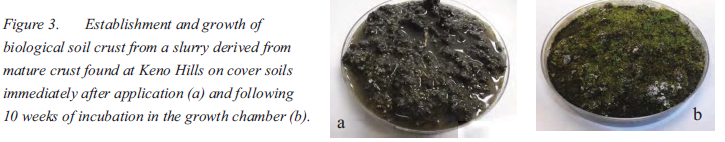
Biological Soil Crusts and Native Species for Northern Mine Site Restoration
Resource
The nitrogen cycle is highly sensitive to pollutants and restoration of this biogeochemical pathway is essential to ensure long-term sustainable ecosystems. In a greenhouse trial, the growth and...
CircumArctic Collaboration to Monitor Caribou and Wild Reindeer
Resource
Caribou and wild reindeer ( Rangifer) are integral to ecology and Aboriginal lives and culture in circumArctic regions. Since reaching peak size in the 1990s, most herds have been declining, while...
Northern Biochar for Northern Remediation and Restoration
Resource
Biochar is a soil amendment that results from heating various biological ingredients, such as wood, fish or animal bone under oxygen limited conditions and has proven to promote plant growth, as well...

Passive Treatment of Mine Drainage Waters: The Use of Biochars and Wood Products to Enhance Metal Removal Efficiency
Resource
Passive biological treatments have been proposed as a possible efficient and cost effective treatment method for metal bearing water discharged from mine sites after closure. Several biofilters are...

Podcast - Shift talks Sacred Science with Alvin First Rider, Brett Purdy, and Emily Herdman
Resource
Alvin First Rider speaks about his nation's use western science alongside Indigenous Knowledge to bring buffalo back to their historical plains.

The Third Generation of Pan-Canadian Wetland Map at 10 m Resolution Using Multisource Earth Observation Data on Cloud Computing Platform
Resource
Development of the Canadian Wetland Inventory Map (CWIM) has thus far proceeded over two generations, reporting the extent and location of bog, fen, swamp, marsh, and water wetlands across the country...

Video - Assessing Cumulative Ecological Effects: The Changing Management Landscape
Resource
Jim Schieck discusses how cumulative effects are currently being assessed in Alberta.

Video - Assessment of forest attributes using airborne and terrestrial LiDAR
Resource
This presentation discusses the different ways that LiDAR data can be effectively used in forestry management applications.

Video - Blood Tribe Buffalo Restoration Project
Resource
Members of the Káínawa – or Blood Tribe – are applying training in western science, alongside their Indigenous Knowledge, to bring buffalo back to their historical habitat in southern Alberta, the...

Video - Building a Sustainable Alberta Through Deployment of LiDAR Technologies: Reflections from an SRD perspective
Resource
Barry White discusses the ways LiDAR is being used by departments within the government of Alberta.

Video - Caribou Conservation Project
Resource
The Denesųłiné of Cold Lake First Nations (CLFN) are applying both their Indigenous Knowledge and expertise in western science to develop and implement diverse caribou conservation strategies in...

Video - Enhanced Fuel Mapping for Wildfire Management
Resource
This presentation discusses ways that LiDAR data can be used in forestry management, including for mapping mountain pine beetle infestations.

Video - Feature Extraction from Multisensor Airborne Data: Monitoring of large-scaled industrial activity on the natural landscape
Resource
This presentation discusses using airborne LiDAR data on monitoring projects with the federal and provincial government. Data collection and data extraction are reviewed.

Video - From Point Cloud to Supporting Decisions: Making use of your LiDAR data
Resource
This presentation discusses how to use LiDAR data, in particular for forestry, but also for other government and industry applications.

Video - High Resolution Inventories Using LiDAR: Challenges and opportunities
Resource
This presentation discuss a pilot project done with Spray Lakes Sawmill FMA related to doing plot inventories using LiDAR.

Video - LiDAR Data Capture and Analysis Standards
Resource
This presentation discusses some of the issues with data collection and analysis that could lead users to require standards.
